Street/Place Names
![]() |
|![]() |
|![]() |
|![]() |
|![]() |
|![]() |
|![]() |
|![]() |
|![]() |
|![]() |
|![]() |
|![]() |
|![]() |
|![]() |
|![]() |
|![]() |
|![]() |
|![]() |
|![]() |
|![]() |
|![]() |
|![]() |
|![]() |
|![]() |
|![]() |
|![]()
Click on any letter, above, to visit specific section of Street/Place Names
|
B.C. Government photo courtesy Royal BC Museum and Archives
|
I-26635
. .. .
|
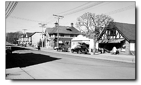 |
Note the original municipal hall in centre of picture
| O | |
|
|
|
|
Oak Bay Avenue |
|
| Named after Oak Bay Beach, a popular destination in the 1880s. | |
| Oak Bay Avenue was built in 1890 by Joseph Despard Pemberton to open his extensive property for development. In 1891 a streetcar line was built and development followed — Mount Baker Hotel (1893), Victoria Golf Club (1893) and Oak Bay Park (1895). The original municipal hall, original high school, and the Oak Bay Grocery (Blethering Place) were built in 1912 | |
| Click on THE TALK ON THE STREET to enjoy the recollections of Richard Goodall | |
|
|
|
Oak Bay Road |
|
| Origin descriptive. | |
| Early name for Bowker Avenue on a 1890 map as it led to John Bowker's "Oak Bay Farm" | |
|
Oakdowne Road |
|
| Origin uncertain, probably descriptive. | |
| Named by the Hudson's Bay Company | |
Oakland Road |
|
| Origin uncertain, probably descriptive. | |
| Former name of Byng Street until 1921 | |
Ochill Street |
|
| Origin unknown, possibly an early settler. | |
| This short, half-block street once extended east from Monterey Avenue into what is now the playing field of Monterey School | |
| Information welcomed | |
|
Oliver Street |
|
| Named after W.E. Oliver, first reeve of Oak Bay. | |
| When the area was being developed in 1912, Oliver Street was promoted as the "Linden Avenue of Oak Bay." It was originally called St. Andrew Street but renamed in 1921. | |
Olympia Avenue |
|
| Origin unknown. | |
| Original name of Estevan Avenue. Renamed Connaught Avenue in 1913 and Estevan Avenue in 1921 | |
Orchard Avenue |
|
| Origin unknown, possibly descriptive. | |
| Information welcomed | |
PLACE NAMES
| Oak Bay Beach | |||||
| Popular public beach in the 1880s and 1890s on Oak Bay adjacent to Turkey Head which included what was later called Rattenbury's Beach (just north of today's marina) and also the small beach immediately south of the marina (the site of the original boathouse). | |||||
| Long before it referred to the land, "Oak Bay" referred only to the water between Turkey Head and Cattle Point | |||||
|
|||||
|
|||||
| see Oak Bay Camp, Rattenbury's Beach | |||||
![]()
The History of Oak Bay Website
A CENTENNIAL LEGACY PROJECT