Street/Place Names
![]() |
|![]() |
|![]() |
|![]() |
|![]() |
|![]() |
|![]() |
|![]() |
|![]() |
|![]() |
|![]() |
|![]() |
|![]() |
|![]() |
|![]() |
|![]() |
|![]() |
|![]() |
|![]() |
|![]() |
|![]() |
|![]() |
|![]() |
|![]() |
|![]() |
|![]()
Click on any letter, above, to visit specific section of Street/Place Names
|
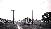
courtesy Royal BC Museum and Archives
|
B-00028
.. . .
|
 |
Note new Willows School behind Uplands streetcar
and old farmhouse that served as first school
| D | |||||||
|
|
|||||||
|
Dalhousie Street |
|||||||
| Origin uncertain, possibly after the Earl of Dalhousie. | |||||||
| So named in 1921 after consolidating Thistle Street (Willows Road to Cadboro Bay Road), Margaret Street (Cadboro Bay Road to Musgrave Street) and Seaview Avenue (Musgrave Street to Willows Beach) | |||||||
Deal Road |
|||||||
| Origin uncertain, possibly after the borough of Deal in Kent, England, reputed to have been the landing place of Caesar in 55 B.C. | |||||||
| Original name of road leading into the South Foreland (Cattle Point area). Subsequently called Sonora Place from the 1930s until the scenic loop was created in 1961. | |||||||
|
Deal Street |
|||||||
| Origin uncertain, possibly after the borough of Deal in Kent, England, reputed to have been the landing place of Caesar in 55 B.C. | |||||||
Deans Cross Road |
|||||||
| Named after Saanich pioneer Geordie Deans. | |||||||
| Early name for Lansdowne Road. Geordie Deans had a farm 1 at Lansdowne Road and Richmond Avenue from the mid 1800s. Deans Cross Road connected his farm to Cadboro Bay Road 2 | |||||||
|
|||||||
| see Dean Heights | |||||||
|
Denison Road |
|||||||
| Named after Frank Napier Denison, Dominion Government Meteorologist at the time the observatory was constructed on Gonzales Hill. | |||||||
| Originally called Highland Drive, renamed in 1921 | |||||||
Devon Road |
|||||||
| Named after Devon, England. | |||||||
Dewdney Avenue |
|||||||
| Probably after Edgar Dewdney, one of Oak Bay's earliest settlers and fifth Lieutenant-Governor of British Coumbia. | |||||||
| Originally called Alexander Avenue, renamed in 1921 | |||||||
| see Edgar Dewdney | |||||||
Dorset Road |
|||||||
| Named after Dorset, England. | |||||||
| Originally called Meadow Road (east of Dunlevy), renamed in 1928 | |||||||
Dover Road |
|||||||
| Named after Dover, England. | |||||||
Downes Road |
|||||||
| Named after Gordon Downes, Principal (1923–29), Oak Bay High School | |||||||
| Downes Road is one of the very few streets in Oak Bay to have disappeared. (If indeed it ever existed. According to old maps, it once ran alongside Bowker Creek, on the north side, between Hampshire Road and the high school) | |||||||
|
|
Dryfe Street |
||||||
| Origin unknown, possibly after an early settler | |||||||
| Originally about half its current length during the days of the Willows fairground, Dryfe Street was extended north to newly-created Woodhouse Road when the fairground was subdivided in the early 1950s. Consequently, different house styles are evident on Dryfe Street, with the older houses in the southerly half | |||||||
|
|||||||
| Click on TUTORIAL for Street Map Tutorial with viewing options | |||||||
|
|
|||||||
| Information welcomed | |||||||
Dufferin Avenue |
|||||||
| Origin uncertain, possibly after Lord Dufferin, Governor General of Canada, 1872–1878. | |||||||
| Originally called Scott Avenue, renamed in 1921 | |||||||
Durham Road |
|||||||
| Origin uncertain, probably after the English city. | |||||||
| Former name of Wales Road prior to c 1940 | |||||||
Dundrum Road |
|||||||
| Origin uncertain, probably Dundrum, Ireland | |||||||
| Named by the Hudson's Bay Company | |||||||
Dunlevy Street |
|||||||
|
|||||||
| Named after Peter C Dunlevy, an early settler prior to 1906. . | |||||||
| Originally called Fourth Street, renamed in 1921 | |||||||
PLACE NAMES
![]()
The History of Oak Bay Website
A CENTENNIAL LEGACY PROJECT