|
M |
|
|
McLaren Avenue
|
|
Named after an early settler in the area. |
|
Information welcomed |
|
McNeill Avenue
|
|
Named after Captain William Henry McNeill, master of the Hudson's Bay Company steamer SS Beaver, and one of the five original landowners of Oak Bay. |
|
McNeill Avenue marks the northern boundary of McNeill's original property |
|
Click on
TUTORIAL
for Street Map Tutorial with viewing options |
|
 |
|
|
|
 |
|
Chief Maquinna
|
|
|
Origin probably after Chief Maquinna of Nootka Sound. |
|
Margaret Avenue |
|
Namesake unknown, possibly local. |
|
Margaret Avenue was a one-block street between Cadboro Bay Road and Musgrave Street. It was renamed Dalhousie Street in 1921 when consolidated with Thistle Street (Willow Road to Cadboro Bay Road) and Seaview Avenue (Musgrave Street to Willows Beach). |
|
Margate Avenue |
|
Named after Margate, England. |
|
Marne Street |
|
|
|
Named in commemoration of the two famous Battles of the Marne in World War One. |
|
Click on
NAMESAKE
to learn namesake of MARNE |
|
 |
|
Marrion Street |
|
Named after Robert Marrion, an early settler before 1906. |
|
Marrion Street is one of the very few streets in Oak Bay to have disappeared due to re-development. It once ran alongside Bowker Creek and cut into the Fort and Foul Bay intersection at an angle. The development of the Marrion Gardens seniors' housing complex and the Oak Bay Recreation Centre saw the end of Marrion Street in the mid 1970s. |
|
Click on
TUTORIAL
for Street Map Tutorial with viewing options |
|
|
|
Information welcomed |
|
Mayhew Street |
|
Probably named after the Honorable R.W. Mayhew, reeve of Oak Bay (1933-1935), federal M.P. and Canadian Ambassador to Japan |
|
Meadow Place |
|
Origin unknown, probably descriptive. |
|
Meadow Road |
|
|
|
Origin descriptive. Meadow Road faced what is now Uplands Park — a primeval Garry oak meadow. |
|
Former name of Dorset Road east of Dunlevy Street |
|
Middowne Road |
|
Origin descriptive, it divides the Lansdowne slope subdivision in half. |
|
Named by the Hudson's Bay Company |
|
Midland Circle |
|
|
|
|
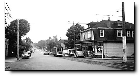
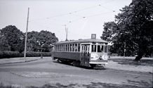
Midland Circle Terminus
Click on image to view enlargement
|
|
|
Origin descriptive, it was the Uplands streetcar terminus on Midland Way. |
|
Midland Circle became the streetcar terminus in the Uplands when the line was extended from The Willows in 1913. |
|
|
With the exception of the streetcar tracks, Midland Circle today looks much as it did nearly one hundred years ago. The streetcar tracks remain buried beneath the pavement at Midland Circle |
|
|
Midland Road |
|
Origin descriptive, it divides the Uplands subdivision in half. |
|
Midland Road originally ran north from Midland Circle until 1939, afterwhich it absorbed Midland Way to the south. |
|
|
Midland Way, Midland Circle and South Circle were intended to form the symmetrical centrepiece of Uplands, but delinquent taxes led to the gift of Uplands Park to the municipality which precluded the realization of this original concept. |
|
|
|
Midland Way |
|
Origin descriptive, it led to the centre of Uplands |
|
Midland Way was conceived as the grand entrance to The Uplands — a three-block, grand-boulevard that connected South Circle with Midland Circle, the streetcar terminus. |
|
|
Lots went on the market in 1912, but the onset of World War I followed by the Great Depression through the 1930s severely curtailed sales. Delinquent back taxes necessitated the forfeiture of land to the Municipality (thereby creating Uplands Park in 1946) which precipitated the demise of Midland Way, today reduced to sections that include two dead-end streets and a country lane. |
|
Of the original grand-boulevard design concept, only Midland Circle has survived. The tracks around the circle remain buried beneath the pavement |
|
|
Click on
TUTORIAL
for Street Map Tutorial with viewing options |
|
|
|
Milton Street |
|
Named after John Milton, English Poet. |
|
Milton Street is one of many streets in the area named after English poets including Goldsmith, Chaucer and Byron |
|
|
Nearby Elgin Road was originally called Burns Street, after Scottish poet Robert Burns |
|
|
Mitchell Street |
|
Named after an early resident (c 1908). |
|
Information welcomed |
|
Monteith Street |
|
Origin uncertain, possibly after W.B. Monteith, an early resident. |
|
Information welcomed |
|
Monterey Avenue |
|
Origin unknown. |
|
Originally called St. George Street but renamed in 1921 |
|
Mount Baker Avenue |
|
Origin descriptive, after the American mountain because of the view from this vantage point. |
|
Original name, until 1921, of the section of Beach Drive between Victoria Golf Course and Bowker Creek |
|
Mountjoy Avenue |
|
Named after "Mount Joy," the former residence of Frederick Bernard Pemberton. |
|
Mowat Street |
|
Probably named after an early resident who lived at 2431 Mowat Street, adjoining the Willows fairgrounds. |
|
| "Mr Mowat (owner of the Victoria Building Company that built the house) sold his home in 1911 for $425 to Mr Richard Skelton." |
| — Steve Duben |
|
|
Information welcomed |
|
Murdoch Crescent |
|
Named after George Murdoch, former reeve of Oak Bay. |
|
Musgrave Street
|
|
Named after John Musgrave of the early firm of Swinerton and Musgrave, Victoria realtors, and commodore of the Royal Victoria Yacht Club. |
|
Originally called Fifth Street but renamed in 1921 |
|
Myrtle Street |
|
Origin unknown. |
|
Former name of section of Victoria Avenue between McNeill Avenue and Granite Street until 1921 |
|
Information welcomed |