Street/Place Names
![]() |
|![]() |
|![]() |
|![]() |
|![]() |
|![]() |
|![]() |
|![]() |
|![]() |
|![]() |
|![]() |
|![]() |
|![]() |
|![]() |
|![]() |
|![]() |
|![]() |
|![]() |
|![]() |
|![]() |
|![]() |
|![]() |
|![]() |
|![]() |
|![]() |
|![]()
Click on any letter, above, to visit specific section of Street/Place Names
|
Robert Loewing photo courtesy John Bromley
|
Gary Wilcox Collection
|
 |
|
.
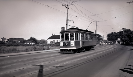
Cadboro Bay Road (September 14, 1946)
.
Uplands streetcar travelling west approaching Epworth Street |
| C | |||||||
|
|
|||||||
|
|||||||
| Named after the bay, which was named after the first European ship to anchor in the bay, the Cadboro. | |||||||
| This was originally a wagon trail that connected Fort Victoria to the HBC's Cadboro Bay Farm in the uplands overlooking Cadboro Bay | |||||||
| Click on THE TALK ON THE STREET to enjoy the 1930s recollections of Phil Ballam | |||||||
|
|
|||||||
Calvert Crescent |
|||||||
| Origin unknown. | |||||||
| Information welcomed | |||||||
Camas Lane |
|||||||
| Origin descriptive, after the wild plant that thrived in local meadows. | |||||||
| This was the boundary between John Tod's property and the Hudson's Bay Company's fur trade reserve (which became known as Uplands Farm) | |||||||
|
Cardiff Place |
|||||||
| Named after Cardiff, Wales. | |||||||
|
Cardigan Road |
|||||||
| Named after Cardigan, Wales. | |||||||
Carnarvon Street |
|||||||
| Named after Caernarfon, Wales. | |||||||
| Originally called Gordon Street, renamed in 1921 | |||||||
|
|||||||
Carrick Street |
|||||||
| Origin Unknown. | |||||||
| Originally called Fourth Street, renamed in 1928 in deference to Carrick Street in Saanich to which it is contiguous | |||||||
| Information welcomed | |||||||
|
Casey's Corner |
|||||||
|
|||||||
| Named after local pioneer shopkeepers Eric and Pearl Casey. | |||||||
| Casey's Corner is the local name give to the intersection of St Patrick Street and Central Avenue, where pioneer shopkeepers, Eric and Pearl Casey, ran a confectionery on the north-east corner since at least the early 1940s | |||||||
| see Eric Casey, Pearl Casey | |||||||
Cavendish Avenue |
|||||||
| Origin uncertain, possibly after William Cavendish, Earl of Newcastle, England. | |||||||
| Originally called Beachway Avenue, renamed in 1921 | |||||||
Cedar Hill Cross Road |
|||||||
| Named after Cedar Hill (Mt Douglas). | |||||||
| Originally an Indian trail between Cedar Hill and Cadboro Bay. It was called Bay Road by early settlers | |||||||
Central Avenue |
|||||||
| Origin descriptive. Central Avenue runs through the middle of the original McNeill property | |||||||
| Click on TUTORIAL for Street Map Tutorial with viewing options | |||||||
|
|
|||||||
Charlton Street |
|||||||
| Origin unknown. | |||||||
| Former name of Newton Street, renamed in 1928 in deference to Newton Street in Saanich to which it is contiguous | |||||||
| Information welcomed | |||||||
Chaucer Street |
|||||||
|
|||||||
| Named after Geoffrey Chaucer, English poet. | |||||||
| Chaucer Street is one of many streets in the area named after English poets including Goldsmith, Milton and Byron | |||||||
|
|||||||
Chiltern Place |
|||||||
| Origin uncertain, possibly after Chiltern Hills, England. | |||||||
| This is one of several cul-de-sacs created in the Uplands during the early 1930s when many large-size lots were subdivided into medium-size lots to encourage sales during the early years of the Depression | |||||||
|
|||||||
Christie Way |
|||||||
| Named after Mrs. M. Christie, a Victoria alderman. | |||||||
| Mrs. Christie was responsible for the subdivision of city-owned property related to the Old Men's Home (Mountain View) | |||||||
Clive Drive |
|||||||
|
|||||||
| Named after Sir Clive Phillipps-Wolley, who built a large home — Woodhall — at the upper end of the street in 1891. | |||||||
| Originally the access road to Phillipps-Wolley's home | |||||||
| Click on THE TALK ON THE STREET to enjoy the 1930s recollections of Patricia Johnston | |||||||
|
|
|||||||
Connaught Avenue |
|||||||
| Origin unconfirmed, but probably after Duke of Connaught, who visited Oak Bay in September, 1912, to bolster Commonwealth solidarity on the eve of World War I. | |||||||
| Former name of Estevan Avenue between 1913 and 1921. Before 1913 it was named Olympia Avenue | |||||||
|
|||||||
Cookman Street |
|||||||
| Origin uncertain, possibly after an early settler. | |||||||
| Information welcomed | |||||||
Cotswold Road |
|||||||
| Origin uncertain, probably after the Cotswold Hills, England. | |||||||
| Click on NAMESAKE to learn namesake of COTSWOLD | |||||||
 |
|||||||
Cranleigh Place |
|||||||
| Named after Cranleigh House, a private school established in 1923 by Charles V. Milton in the former Willows Hotel building. | |||||||
| The school was converted to a four-plex before being demolished in 1968 to make way for the Cranleigh Apartments at 2189 Cadboro Bay Road | |||||||
Cranmore Road |
|||||||
| Named in 1908 after two pioneer residents, Ross Crane and Albert Henry Blakemore. | |||||||
| Fomerly called Todd Road from 1902 until 1908. Originally called Tod's Road on subdivision map. | |||||||
Crescent Road |
|||||||
| Origin descriptive. | |||||||
Crestview Road |
|||||||
| Origin descriptive. | |||||||
Cubbon Drive |
|||||||
| Named after Harold Cubbon, one of the subdividers of the former MacDonald property. | |||||||
| Cubbon Drive is a short road that serves the subdivision | |||||||
Currie Road |
|||||||
| Named after Lieutenant General, Sir Arthur Currie, C.B., K.C.M.G., commander of the Canadian forces in World War I. | |||||||
| Originally called Longbranch Avenue, renamed in 1923 | |||||||

PLACE NAMES
![]()
The History of Oak Bay Website
A CENTENNIAL LEGACY PROJECT