|
J
|
|
|
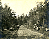
Junction Road
c1890–c1912 |
|
Oak Bay Archives
|
1997-002-001 |
 |
Junction Road
circa 1904
|
Click on image to view enlargement |
|
|
Junction Road probably started as a wagon trail carved across undeveloped land to connect early pioneers of south Oak Bay to Willows Fairgrounds. |
|
This trail had a dogleg that connected Oak Bay Avenue to Cadboro Bay Road at the point where Willow Road led to the fairgrounds. |
|
By 1904 this land was subdivided and lots had been sold.1 |
|
With subdivision, the days were numbered for the dogleg veering to the fairgrounds. The dogleg was realigned, on paper, to connect with Cranmore Road to conform with the subdivision grid. |
|
In 1908 the municipality purchased the right-of-way for this realignment.2 |
|
In 1909, Junction Road was realigned to connect Oak Bay Avenue with Cranmore Road.3 |
|
By 1912, Junction Road was being called North Hampshire Road in deference to Hampshire Road south of Oak Bay Avenue.4 |
|
In 1926, North Hampshire Road was incorporated into Hampshire Road.5 |
|
Junction Road was never an official street. Although it appeared on some old maps as a trail through undeveloped land, it wasn't listed in city street directories because no addresses were assigned for, nor any houses built on, Junction Road. |
|
|
1 Stark, Stuart. Oak Bay's Heritage Buildings: More than just Bricks and Boards. (The Hallmark Society: 1986) p 14 |
|
2 Ibid. |
|
3 Murdoch, George. A History of the Municipality of Oak Bay. (Oak Bay Municipality: 1968) p 35 |
|
4 Henderson's Victoria Street and Avenue Directory for 1912. p 179 |
|
5 Wrigley's Victoria Street and Avenue Directory: 1926. p 1377 |
|